- By Akansha Pandey
- Tue, 22 Jul 2025 04:26 PM (IST)
- Source:JND
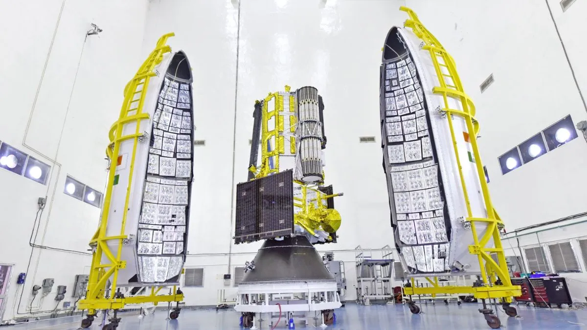
NISAR Satellite Mission date 2025: US space agency, National Aeronautics and Space Administration (NASA), and the Indian Space Research Organisation (ISRO) will launch their first joint satellite, NISAR (NASA- ISRO Synthetic Aperture Radar), on July 30, 2025, from the Satish Dhawan Space Centre in Sriharikota. Aimed to advance US-India cooperation in civil space cooperation, the NISAR satellite will provide high-resolution data enabling scientists to comprehensively monitor the planet’s land and ice surfaces. NISAR will be launched through ISRO’s GSLV-F16 rocket.
🌍 Historic Launch Ahead: ISRO Set to Launch NISAR, a joint satellite with NASA !
— ISRO (@isro) July 21, 2025
🚀 On July 30, 2025 at 17:40 IST, ISRO’s GSLV-F16 will launch #NISAR, the first joint Earth observation satellite by ISRO & NASA, from Sriharikota.
🛰️ NISAR will scan the entire globe every 12… pic.twitter.com/4Mry076XSZ
What is the NISAR Mission of NASA and ISRO?
According to the ISRO, NISAR is a 2392-kg powerful Earth-observation satellite that will provide detailed three-dimensional (3D) images of our planet. NISAR is a first-of-its-kind satellite which will use dual-frequency radar. It consists of ISRO’s S-band and NASA’s L-band synthetic aperture radar integrated with a 12-meter antenna of NASA and a 13K modified satellite bus of ISRO. With high resolution using SweepSAR technology, this satellite will observe a wide area of 242 kilometres and allow detailed 3d mapping of Earth’s land and ice surfaces with unprecedented accuracy.
Aim Behind NISAR Mission
ISRO and NASA have designed Nisar to observe and quantify some important planetary phenomena. These are:
- Nisar's work is to detect centimetre-level changes in the Earth's crust to monitor earthquakes, volcanoes and landslides.
- It will be very important for climate models as it will track the movement and melting of polar ice sheets.
- It will assess changes in forest cover, crop growth and vegetation for sustainable agriculture.
- Nisar will also monitor changes in soil moisture, surface water and wetlands for water resource management.
- Nisar has been created for important work like providing real-time data for relief operations after cyclones, tsunamis, floods and forest fires and monitoring coastal erosion, sea ice and maritime traffic for safety and environmental protection.
Global Impact of the NISAR Satellite Mission
The NISAR Satellite mission is not only to understand, improve and protect the Earth, but it also symbolises how international collaboration between important organisations can advance science and technology and provide benefits for the company.
The extensive data from this mission will empower governments, researchers and disaster-response teams around the world. It will help them make better decisions in areas such as food security, environmental protection, urban planning and mitigating the effects of climate change.
The mission also marks a new chapter in the growing collaboration between the two space agencies. Years in the making, the launch of NISAR builds on a strong heritage of successful programs, including Chandrayaan and the recent Axiom Mission 4, which saw ISRO and NASA astronauts living and working together aboard the International Space Station for the first time.