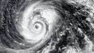
Cyclone Alert: The India Meteorological Department (IMD) on Friday has issued a cyclone alert that could affect various parts of Odisha and Andhra Pradesh in the coming days. According to the weather department, a low-pressure area over the East Central and adjoining Southeast Bay of Bengal is likely to intensify into a deep depression on October 24. It will further turn into a deep depression on October 25, finally turning into a cyclonic storm over the West Central Bay of Bengal by October 26 morning.
Extremely Heavy Rain Alert In Andhra, Odisha
As the cyclonic storm is likely to intensify further and move west-northwestwards towards North Andhra Pradesh and adjoining South Odisha coasts during the next two days, it can bring isolated extremely heavy rainfall over coastal Andhra Pradesh on October 27 and 28. It would also have an impact on Odisha on October 28.
Isolated heavy to very heavy rainfall is also likely over Odisha on October 27 and 29.
Will It Be Named Cyclone Arnab?
If this depression turns into a cyclone, it will be named 'Arnab', as per the roster that lists names of cyclonic storms. In Bengali, the term 'Arnab' means ocean. The name was suggested by Bangladesh to the regional tropical cyclone naming list. This naming list is looked after by the IMD and WMO (World Meteorological Organisation).
How IMD Classifies Depressions
The India Meteorological Department (IMD) classifies low-pressure systems based on how they develop and how strong they become. Over land, the classification depends on the pressure pattern, while systems over the sea are judged mainly by wind speed. A low-pressure area is marked by a single closed isobar. A depression has two closed isobars, and a deep depression has three. Once a system develops four or more closed isobars, it is placed in the cyclonic storm category.
ALSO READ: Mumbai Weather Update: No Immediate Relief From Heat As IMD Issues Yellow Alert | Check Forecast
Wind speed is another important factor. A depression has maximum sustained winds of 17–27 knots (31–50 kmph), while a deep depression carries winds of 28–33 knots (52–61 kmph). When the wind speed reaches 34 knots (63 kmph) or more, the system is called a cyclonic storm.
This means that a simple formation of a low-pressure area does not automatically mean a cyclone is forming. The system has to strengthen further and meet the given criteria before it is classified as one.