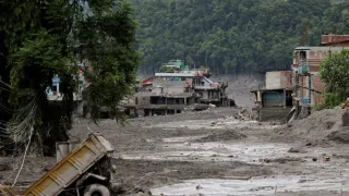
Nepal is currently reeling from one of the biggest natural disasters the country has ever seen as flash floods ravaged the Trishuli Valley and claimed the lives of over 939 people while over 4,000 still remain missing. With rescue and relief operations going on at war footing, concerns have been raised about what triggered the floods, especially because the region has historically been prone to such disasters.
Initially, it was reported that an earthquake or the glacial lake outburst flood (GLOF) could be the most probable cause behind the floods, but the recent study by the Nepal Environment Society (NES) has ruled out these possibilities.
It stated that the flash flood was caused by a massive ice rock fall.
Key findings of the study
- Ice-rock fall: The study commissioned by the NES found that a huge mass of ice, rock and debris fell from around 5,200 metres in the Langtang Lirung area of Rasuwa and entered the Lhende River. This generated a powerful debris-laden flood that advanced downstream through the Bhotekoshi and Trishuli rivers.
- No lake burst: Bishal Nath Upreti, president of the Nepal Centre for Disaster Management, told news agency PTI that no glacial lake had burst in Tibet and hence it could not cause the floods. "Initially, many thought it was a glacial lake outburst flood, or GLOF. Later, it became clear that there had been no lake burst in Tibet along that line, so that theory was discarded," he said.
NES researchers analysed satellite imagery, hydrological and meteorological data, terrain characteristics and changes in elevation and slope along the river system to rule out the lake outburst. - Ice-rock movement: The study found that a massive ice-rock began falling from the northern part of Langtang Lirung at around 8:37 am on Wednesday. It fell steeply from about 5,200 metres to reach the Lhende River at around 2,930 metres.
The researchers analysed the satellite images, which showed major geographical changes across about 10 sq km as a section of glacier covering approximately 0.56 sq km had broken away.
The fallen ice-rock mass travelled about 22 km to Rasuwagadhi in just over seven minutes, at an estimated average speed of 167 kmph. Between Rasuwagadhi and Betrabati, its speed was reduced to 73 kmph and further to 22 kmph downstream. The ice-rock slowed down but had already carried huge quantities of rock, sediment and soil to leave a trail of devastation and bring the same downstream. - No excessive rainfall: The study also found that there was no exceptionally heavy rainfall to cause flash floods in the upper areas. This rules out not only rain but also cloudburst as a probable cause behind the disaster.
- Another flood: Upreti said that three hours and eight minutes after the first event, another landslide occurred which formed a temporary dam at the river channel. The water buildup breached it, causing another smaller flood. "Fortunately, it flowed slowly and did not result in a major disaster," he said.
- Situation evolving, cause remains uncertain: Upreti also said that scientific interpretations change rapidly as new information emerges and as per the latest available information, the cause remains ice-rock fall but cautioned that it still remains uncertain.
(With PTI Inputs)