India's Home Minister Amit Shah's recent visit to Harami Nala, one of the most sensitive and mysterious stretches of the India-Pakistan border, has drawn fresh attention to this remote and treacherous waterway in Gujarat's Kutch district.
(Union Home Minister and Minister of Cooperation Shri Amit Shah interacts with personnel at G-7 Border Out Post, situated along India-Pakistan border in Bhuj | CREDIT: PIB)
Where is Harami Nala?
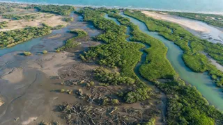
Located in the Sir Creek region, Harami Nala is not an ordinary creek. It is a 22-kilometre-long tidal channel that snakes through vast marshlands, dense mangrove forests, and ever-shifting mudflats. This narrow waterway forms a natural yet complicated part of the India-Pakistan frontier, where the boundary remains unsettled even after decades.
How did Harami Nala get its name?
What makes Harami Nala truly unique is its deceptive and dangerous character, the very reason it earned its notorious name. In fact, the government of India is using the term Harami Nala in its official press releases.
(India officially uses Harami Nala in its press statements | CREDIT: PIB)
ALSO READ: What Is Sir Creek Dispute? Why India And Pakistan Failed To Resolve It | All You Need To Know
In Hindi, "Harami" is often used as slang for a rogue or treacherous person. Here, the name perfectly describes the channel’s unpredictable nature. Its twisting paths, rapidly changing tides, and shallow waters can trap boats and vehicles within hours.
What appears as a calm, navigable stream at low tide can suddenly turn into a dangerous maze of swirling currents and sinking mudflats. Many unfamiliar travellers have found themselves lost or stranded in this confusing network of creeks.
Complex India-Pakistan border
Historically, this geographical complexity has made Harami Nala a preferred route for smugglers, infiltrators, and illegal cross-border activities. The maritime boundary in the Sir Creek area adds another layer of difficulty for security forces. The absence of a clearly defined line on the map, combined with the hostile terrain, creates constant challenges for the Border Security Force (BSF).
Thick mangroves and shallow channels provide excellent hiding spots, forcing security agencies to maintain round-the-clock vigil using boats, drones, and advanced surveillance.
Why is 'Harami Nala' important?
Despite its inhospitable environment, the region is also ecologically rich and serves as an important fishing ground for local communities. The creek system supports livelihoods but simultaneously remains a strategic vulnerability.
Amit Shah’s visit underlines the government’s serious focus on strengthening border management in even the most remote and difficult terrains. By personally inspecting Harami Nala, the Home Minister has signalled that no stretch of the border, however challenging, will be neglected.
From a geographical puzzle and smuggler’s paradise to a critical security zone, Harami Nala represents the complex realities of guarding India’s western frontier, where nature itself acts as both a barrier and a threat. As India continues to modernise its border infrastructure, this “rogue channel” will remain a key test of the country’s resolve to secure its coastline and marshes.