- By Ridam Sharma
- Fri, 09 May 2025 12:07 PM (IST)
- Source:JND
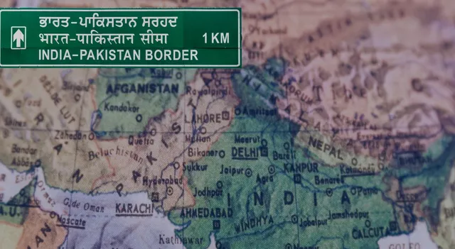
Indian States That Share Border With Pakistan: The brutal Pahalgam terror attack in Kashmir on April 22, 2025, worsened relations between neighbouring countries and brought the India-Pakistan relationship back into the headlines. As far as the border is concerned, India shares a 3,323 km long border with Pakistan, which is known as the International Border (IB). It stretches from the northernmost union territories to the western state of Gujarat. This border is one of the most dangerous, geopolitically sensitive and heavily guarded. The several sections of this border are also referred to as the Line of Control (LOC) in disputed regions.
List Of Indian States And Union Territories That Share Borders With Pakistan, According To The Ministry Of Home Affairs Data:
| State/UT | Border Length (km) | Border Name/Section |
|---|---|---|
| Jammu & Kashmir | ~1,222 | Line of Control (LoC), IB |
| Ladakh | ~857 | AGPL, LoC |
| Punjab | 425 | International Border (IB) |
| Rajasthan | 1,048 | International Border (IB) |
| Gujarat | 512 | International Border (IB) |
Note: Border lengths may vary slightly across sources due to demarcation differences.
Jammu and Kashmir
Jammu & Kashmir, which was a princely state, is now a union territory following the abolition of Article 370. The state shares the dangerous Indian border with Pakistan and most of which is referred to as the Line of Control (LoC). The area is hilly, with a mixed population and a high military presence because of ongoing disputes since years of Independence. The border here is especially sensitive, with regular ceasefire violations and security issues.
Ladakh
Ladakh is India's northernmost union territory, which was established in 2019 following the bifurcation of Jammu and Kashmir. It is bordered by Pakistan in the Gilgit-Baltistan area, called the Actual Ground Position Line (AGPL) in the Siachen region. Ladakh's border is inaccessible with high altitude and strategically critical situations. The border also touches China and Afghanistan.
Punjab
Punjab is situated in northwestern India and shares a 425 km border with Pakistan's Punjab province. The border is widely known for the Wagah-Attari crossing, where the Beating Retreat ceremony is performed daily. The area is fertile and historically important, which was partitioned during the Independence in 1947.
Rajasthan
Rajasthan is India's largest state in terms of space, and is bordered by Pakistan's Sindh and Punjab provinces on a 1,048 km long border. The border touches the Thar Desert, which makes it an exceptionally dry terrain with difficult security logistics. Munabao is a major border site with a major integrated check post for trade.
Gujarat
Gujarat is a western Indian state that shares a 512 km border with Pakistan. The frontier runs through the salt flats of the Rann of Kutch and is marked by the Zero Point at the south-western terminus. There have been incidents of conflict here in the past, like the 1965 Rann of Kutch incident.
What Is the India-Pakistan Border Named?
International Border (IB): The formally recognised border between India and Pakistan, which passes through Punjab, Rajasthan, and Gujarat. It is also known as the Radcliffe Line.
Line of Control (LOC): The military line of control dividing Indian and Pakistani-controlled areas of Jammu and Kashmir.
Actual Ground Position Line (AGPL): The line demarcating Indian and Pakistani positions in the Siachen Glacier area, which is mainly in Ladakh.
India's border with Pakistan runs along three Indian states- Punjab, Rajasthan, Gujarat- and two union territories- Jammu and Kashmir, Ladakh. According to the area and context, the border names are differentiated as the International Border, Line of Control and Actual Ground Position Line. Every border has distinct geographical, historical, and strategic importance, making the Indo-Pak border one of the most complicated and sensitive in the world.