- By Supratik Das
- Tue, 01 Jul 2025 02:17 PM (IST)
- Source:JND
Australia's most populous state, New South Wales, is suffering from extreme weather as a strong bomb cyclone strikes the coast with strong rain, devastating gusts, and perilous surf, issuing evacuation alerts and large-scale flight cancellations. Resulting in strong and damaging winds, torrential rains, heavy snowfall, flooding, and frigid temperatures. It displays some traits of a hurricane, but it is not one.
Severe weather warnings have been issued by the Bureau of Meteorology for Sydney's metropolitan area and coastal towns. Forecasts indicate 299 mm of rain in the next 48 hours, which is twice the city's average July rainfall. Gusty winds of up to 125 km/h are forecast to batter the coast, increasing the risk of trees being uprooted, power outages, and flash flooding. Emergency Services Minister Jihad Dib told that the scale of the system was "enormous" and warned residents to prepare for deteriorating conditions. "It looks bad, but the worst thing is the situation is going to get worse over the next 24 hours," Dib told a press conference on Tuesday.
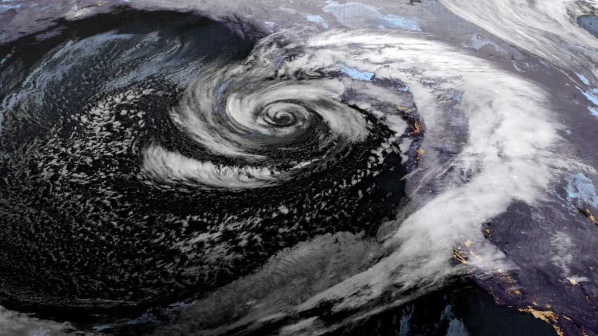
What Is A Bomb Cyclone?
A bomb cyclone, also referred to by meteorologists as bombogenesis, is a low-pressure system that rapidly develops and is characterized by a dramatic and rapid decrease in atmospheric pressure. A cyclone is a low-pressure weather system, one where the atmospheric pressure is lower at its center than in surrounding areas, with winds rotating inward. It circulates in a counterclockwise direction in the northern hemisphere and a clockwise direction in the southern hemisphere. Based on the Bureau of Meteorology (BOM) of Australia, the system that is currently offshore from New South Wales has gone past the critical point, with pressure falls of up to 24 hectopascals per day, driving out-of-control weather over Sydney and surrounding areas.
A bomb cyclone's winds can reach hurricane force, 74 miles (119 km) per hour, and stronger. These storms tend to form during winter and can spawn copious amounts of precipitation. They have life spans of about a week during which they grow to peak intensity over roughly four to five days and then dissipate over the last two, according to Jon Martin, a professor of meteorology at the University of Wisconsin at Madison.
Bomb cyclones are created when the storm intensifies under favorable surface and jet stream conditions. In the high atmosphere, a small band of powerful winds is known as the jet stream. These storms are the result of a number of atmospheric processes. Nearly every bomb cyclone begins with a disruption in the winds in the center of the troposphere, which is the lowest section of the Earth's atmosphere, and lasts for three to five miles (five to eight kilometers). Another important feature common to many, but not all, explosive cyclogenesis events is a warm ocean surface. Many of the most intense bomb cyclones form over oceans. Precipitation can be prodigious. When water vapor changes into liquid and ice, as it does in these storms, enormous amounts of energy, called latent heat energy, are released. Some of that energy further intensifies the storm. By the atmospheric pressure getting so low, differences in pressure across the storm can become very large, powering strong winds that can have devastating effects
Is Sydney Frequently Affected By Cyclones?
Global climate change, according to experts cited by Reuters, is causing more frequent and more extreme weather events around the world. But are bomb cyclones becoming more common or more intense? Martin said it is not clear whether that is the case. The fact that Earth is warming has ramifications for cyclone dynamics that scientists are currently trying to figure out, Martin said. A warmer planet means more water vapor in the air, and that would tend to make at least the latent heat portion of the empowerment of these storms stronger, Martin said. However, the warming is not uniform, Martin said. Since observations suggest more warming at high latitudes, Martin said, this could render the bomb cyclones weaker in general. Cyclones rarely hit Sydney directly due to its latitude, but remnants of tropical cyclones and powerful east coast lows can still bring destructive weather. Notable systems in recent history include Cyclone Nancy in 1990 and ex-Cyclone Oswald in 2013.
The severe weather has compelled airlines to cancel several flights. Qantas Airways grounded at least 11 domestic flights out of Sydney Airport, while Virgin Australia cancelled 12 flights because of unsafe conditions in Sydney and Newcastle. International flights are as yet unaffected. People living in flood-prone and coastal erosion areas along the Mid North Coast and Illawarra Coast have been advised to evacuate as a precautionary measure. Minor flood levels have also been predicted for the Hawkesbury-Nepean, Hunter, and Snowy River catchments. The worst effects will be experienced on Tuesday and Wednesday, with the system set to move into the Tasman Sea by Wednesday evening and ease off gradually by Thursday, the BOM said. Senior Meteorologist Helen Reid stated large swells and damaging winds would persist through Wednesday before gradually improving from Friday.
ALSO READ: Rare 'Roll Cloud' Spotted Over Portuguese Beach Amid Severe Heatwave: Watch Viral Video