- By Prateek Levi
- Thu, 06 Nov 2025 02:25 PM (IST)
- Source:JND
Google Maps has announced one of its most extensive updates for India, introducing 10 new AI-powered and India-first features that aim to make travel safer, navigation smarter, and everyday journeys more seamless.
This rollout integrates Google’s Gemini AI with Maps’ trusted real-world data, bringing a mix of conversational navigation, proactive safety alerts, and locally designed travel tools.
ALSO READ: macOS Tahoe 26.1 And iPadOS 26.1 Deliver Fresh Look And Improved Functionality
Lalitha Ramani, General Manager, Google Maps, India, said:
“Our approach in India has always been to combine our leading AI technologies with a deep, local understanding. Today, Maps takes a significant leap forward with the power of Gemini, enabling a conversational, intuitive, AI-powered assistant to make everyday journeys smarter and easier. We are also updating Maps with new safety initiatives developed with local authorities—like our partnerships with NHAI for real-time highway information and local authorities for accident-prone area alerts—all of which embody our ongoing commitment to building a map that is truly for India.”
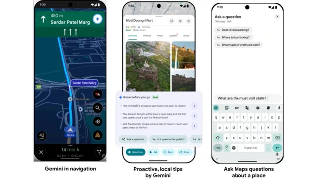
1. Hands-Free Navigation with Gemini
AI-powered conversations while driving
The biggest highlight of this update is Gemini’s arrival in Maps. Drivers can now experience a hands-free, conversational navigation mode, allowing them to ask natural questions like “Find the nearest petrol pump” or “What’s parking like there?” without touching their screen.
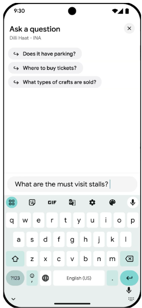
Image Credits: Google
Gemini also handles multi-step tasks such as finding a restaurant and then adding it to the user’s calendar, seamlessly integrating with Gmail and Google Calendar with permission. It’s designed to act like a smart co-pilot, keeping users focused on the road.
2. Proactive Local Tips by Gemini
Insider insights before you arrive
Gemini will now proactively analyse Maps reviews and web content to provide short, relevant tips about popular destinations — before users even arrive. Visiting Delhi’s Dilli Haat? Maps might suggest “It’s okay to bargain for prices” or highlight that “the momos in the Nagaland stall are highly rated.”
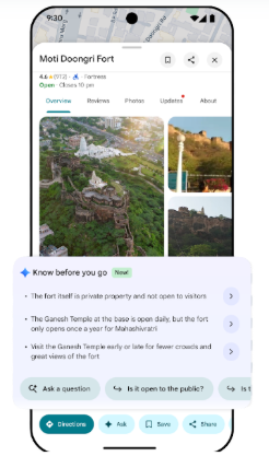
Image Credits: Google
These insights transform how users explore, making planning more intuitive and locally informed.
3. Ask Maps Questions
Instant, AI-backed answers about any place
Users can now ask specific questions directly in Maps, like “Does Dilli Haat have parking?” or “What are some must-visit stalls?” Gemini uses Maps’ reviews, photos, and place data—along with web content—to give detailed, context-aware responses.
4. Proactive Traffic Alerts
Stay updated on delays before you start driving.
Google is rolling out Proactive Traffic Alerts in India, one of the first markets globally to receive it after the U.S. Even when not in navigation mode, Maps will now notify users of major traffic disruptions or delays ahead, helping them plan better.
The feature launches first for Android users in New Delhi, Mumbai, and Bangalore.
5. Accident-Prone Area Alerts
Visual and voice warnings for high-risk zones
To improve road safety, Maps will now alert drivers when they are approaching accident-prone areas, based on verified data from local authorities. Both visual and voice alerts will encourage drivers to slow down and stay cautious.
This India-designed feature begins rolling out in Gurugram, Cyberabad (Hyderabad), Chandigarh, and Faridabad.
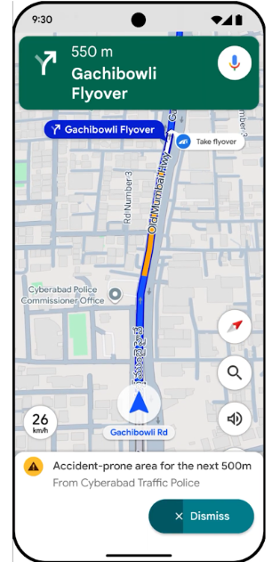
Image Credits: Google
Official Speed Limits on Maps
Real-time, authority-sourced speed data
Google Maps will now display official speed limits right next to the in-app speedometer while navigating. The feature relies on authentic data from traffic authorities and is meant to promote safer driving habits.
It’s rolling out to both Android and iOS users in nine cities—Faridabad, Ghaziabad, Gurugram, Hyderabad (including Cyberabad), Jaipur, Kolkata, Lucknow, Mumbai, and Noida.
Partnership with NHAI
Real-time highway data for safer journeys
Google has partnered with the National Highways Authority of India (NHAI) to deliver real-time information on road closures, repairs, and conditions through Maps. The collaboration, powered by API Setu, will also surface details about wayside amenities such as toilets, eateries, and petrol stations.
Shri Vishal Chauhan, Member Admin, National Highways Authority of India (NHAI), said:
“At NHAI, our mission is to create a safe and efficient National Highway system for all. We are happy to partner on this journey with Google Maps, a critical daily companion for millions that has consistently demonstrated a commitment to building for India's unique needs. This collaboration, powered via API Setu, allows us to deliver our authoritative and fresh data on national highways directly to the public as they use Google Maps. It is a significant step forward in our Digital India vision, empowering citizens with the information they need to travel more safely and confidently.”
8. Customisable Two-Wheeler “Navatars”
Personalise your on-screen ride.
Recognising India’s massive two-wheeler community, Google Maps has introduced Navatars — customisable icons for motorbikes and scooters. Riders can now choose from classic, sports, or scooter types in eight vibrant colours, adding a touch of personality to their navigation screen.
![]()
Image Credits: Google
9. Voice Navigation for Flyovers
Clearer, localised voice guidance
Building on its India-first flyover navigation system, Maps now supports voice instructions in nine Indian languages, helping users approach complex junctions and flyovers with ease. This feature especially benefits two-wheeler riders who rely on hands-free guidance.
10. Google Wallet Integration for Metro Tickets
Seamless ticket access during travel
Following its ONDC partnership for metro bookings, Maps now integrates with Google Wallet so users can save and access metro tickets directly from Maps. The feature is live in Delhi, Bangalore, Kochi, and Chennai, with Mumbai launching soon—making commutes simpler and faster.
Strengthening India’s Mapping Ecosystem
These updates reinforce Google’s local-first strategy for India. Over the past year, the company has scaled unique features such as flyover callouts and narrow road navigation, expanded EV charging and public transport data through collaborations with Tata Power, ONDC, and Namma Yatri, and surfaced over 150,000 disruption alerts daily.
Dr Rajesh Kumar Mohan, IPS, Deputy Commissioner of Police, Traffic, Gurugram, said:
“We are thrilled to deepen our collaboration with Google Maps, a crucial collaborator in our efforts to make daily navigation more efficient for our citizens. By integrating data such as speed limits and accident-prone area alerts, we are influencing the choice architecture of the drivers with subtle nudges towards road safety. We look forward to continuing this work to explore further data-driven solutions that enhance road safety for everyone in Gurugram.”
Shri Rupesh Kumar, IPS, Joint Commissioner of Police, Traffic, Kolkata, added:
“In our mission to emphasise the Safe Drive Save Life campaign and to build a modern, safe, and efficient Kolkata, strong partners like Google play a critical role. We share a long-standing goal of making journeys more seamless for citizens, having already collaborated on areas like real-time road disruption alerts and traffic flow optimisation. We are pleased to expand this collaboration by integrating our speed limit data directly into Google Maps. This puts critical, official information right where drivers need it most—on the navigation screen they’re already using. We hope this will encourage more responsible driving and help make Kolkata’s roads safer for everyone.”
ALSO READ: Samsung Galaxy XR Headset Could Get Global Launch In 2026
A Map Built for India
With Gemini-powered AI, safety partnerships, and uniquely local travel tools, Google Maps is evolving from a navigation app into a context-aware travel assistant – one that understands India’s roads, languages, and travel behaviours like never before.