- By Aditi Priya Singh
- Tue, 07 Oct 2025 04:09 PM (IST)
- Source:JND
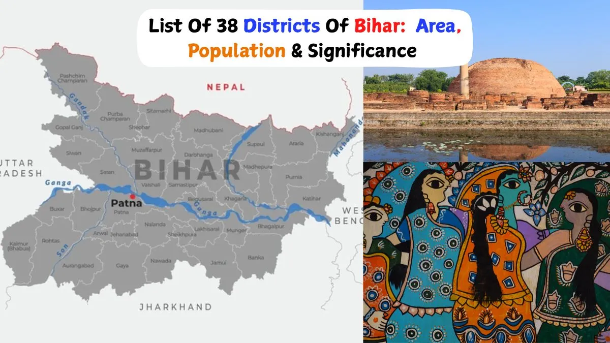
List of Bihar's 38 Districts: Bihar, located in eastern India, is a state known for its rich history, culture and political significance. With 38 districts, Bihar is gearing up for its upcoming state assembly election, scheduled to take place on 6 and 11 November 2025. Both the BJP and the RJD are competing to their best in this election. The election is set to be a significant event that will shape the future governance and development of the state. Each district, with its unique demographic profile and challenges, will play a crucial role in determining the electoral outcome. The election is expected to bring key development issues to the forefront, including infrastructure, education and rural development, as candidates focus on addressing the needs of their constituents.
Districts such as Patna, East Champaran and Gaya will witness intense political activity as parties compete for voter support. Effective administration within these districts is vital for smooth electoral processes, ensuring that every eligible voter can participate. Overall, the election will be a milestone for Bihar, reflecting the aspirations of its people and the evolving political landscape of this historic state.
Role Of Bihar’s Districts In State Development
Each of the 38 districts that make up Bihar functions as a basic administrative division. To effectively manage governance, these districts are further subdivided into blocks and subdivisions. By carrying out welfare programs, health initiatives, educational programs and infrastructure projects, they significantly contribute to the state's development. By bridging regional disparities, districts assist in ensuring that government services are accessible to both urban and rural populations.
They are also essential for tracking social development, agricultural productivity, and economic growth. Since every district advances Bihar as a whole, they are essential to the state's administrative planning and policy implementation.
List of 38 Districts in Bihar with Their Subdivisions, Area, Population and Significance
| S. No. | District Name & Headquarters | Area (km²) | Population Census data (2011) | Administrative Subdivisions (Anumandal) | Significance |
|---|---|---|---|---|---|
| 1 | Araria | 2,830 | 2,811,569 | Araria, Forbesganj | Important for agriculture and trade with Nepal |
| 2 | Arwal | 637 | 699,000 | Arwal | Known for its cultural heritage and rural economy |
| 3 | Aurangabad | 3,303 | 2,540,073 | Aurangabad, Daudnagar | Rich historical sites and mineral resources |
| 4 | Banka | 3,018 | 2,034,763 | Banka | Known for forest resources and Shakti Peeth temples |
| 5 | Begusarai | 1,917 | 2,970,541 | Begusarai, Teghra, Manjhaul, Bakhri, Balia | Industrial and agricultural hub |
| 6 | Bhagalpur | 2,569 | 3,037,766 | Bhagalpur Sadar, Kahalgaon, Naugachhia | Famous for silk production, the "Silk City" |
| 7 | Bhojpur (Arrah) | 2,473 | 2,728,407 | Arrah Sadar, Jagdishpur, Piro | Historical importance in the freedom movement |
| 8 | Buxar | 1,624 | 1,706,352 | Buxar, Dumraon | Archaeological sites and agricultural economy |
| 9 | Darbhanga | 2,278 | 3,937,385 | Darbhanga Sadar, Benipur, Biraul | Cultural centre with rich Maithili heritage |
| 10 | East Champaran (Motihari) | 3,968 | 5,099,371 | Motihari, Areraj, Chakia, Pakri Dayal, Raxaul, Sikrahana(Dhaka) | Site of Mahatma Gandhi’s Champaran Satyagraha |
| 11 | Gaya | 4,978 | 4,391,418 | Gaya Sadar, Neemchak Bathani, Sherghati, Tekari, Wazirganj | Religious significance, Bodh Gaya Buddhist heritage |
| 12 | Gopalganj | 2,033 | 2,562,012 | Gopalganj, Hathua | Agricultural economy and political significance |
| 13 | Jamui | 3,099 | 1,760,405 | Jamui | Mineral-rich region, especially for coal |
| 14 | Jehanabad | 1,569 | 1,125,313 | Jehanabad | Historical role in regional politics |
| 15 | Kaimur (Bhabua) | 3,363 | 1,626,384 | Bhabua, Mohania | Rich in natural resources and forests |
| 16 | Katihar | 3,056 | 3,071,029 | Katihar, Barsoi, Manihari | An important rice and jute-producing district |
| 17 | Khagaria | 1,486 | 1,666,886 | Khagaria, Gogri | An agricultural base with flood-prone areas |
| 18 | Kishanganj | 1,884 | 1,690,400 | Kishanganj | Tea production and unique cultural diversity |
| 19 | Lakhisarai | 1,228 | 1,000,912 | Lakhisarai | Small district with cultural and religious sites |
| 20 | Madhepura | 1,788 | 2,001,762 | Madhepura, Uda Kishunganj | Agriculture and flood management challenges |
| 21 | Madhubani | 3,501 | 4,487,379 | Madhubani, Benipatti, Jhanjharpur, Phulparas | Famous for Madhubani art and cultural heritage |
| 22 | Munger | 1,419 | 1,367,765 | Munger, Kharagpur | Historical forts and a rich cultural tradition |
| 23 | Muzaffarpur | 3,173 | 4,801,062 | Muzaffarpur East, Muzaffarpur West | The major lychee-producing district |
| 24 | Nalanda (Bihar Sharif) | 2,354 | 2,877,653 | Bihar Sharif, Rajgir, Hilsa | Ancient Nalanda University, UNESCO World Heritage |
| 25 | Nawada | 2,492 | 2,219,146 | Nawada, Rajauli | Agricultural district with historical significance |
| 26 | Patna | 3,202 | 5,838,465 | Patna Sadar, Patna City, Barh, Danapur, Masaurhi, Paliganj | Capital city, political and educational centre |
| 27 | Purnia | 3,228 | 3,264,619 | Purnia Sadar, Banmankhi, Baisi, Dhamdaha | Agricultural and trade hub in northern Bihar |
| 28 | Rohtas (Sasaram) | 3,850 | 2,959,918 | Sasaram, Dehri-on-Sone, Bikramganj | Rohtasgarh Fort and rich mineral resources |
| 29 | Saharsa | 1,696 | 1,900,661 | Saharsa Sadar, Simri Bakhtiyarpur | Agricultural district prone to floods |
| 30 | Samastipur | 2,905 | 4,261,566 | Samastipur Sadar, Dalsinghsarai, Rosera, Patori | Cultural centre with agricultural importance |
| 31 | Saran (Chhapra) | 2,641 | 3,951,862 | Chhapra, Marhaura, Maharajganj | Historical and cultural significance |
| 32 | Sheikhpura | 689 | 636,342 | Sheikhpura | Smallest district, known for agriculture |
| 33 | Sheohar | 443 | 656,246 | Sheohar | The least populous district with tribal and rural areas |
| 34 | Sitamarhi | 2,199 | 3,423,574 | Sitamarhi Sadar, Pupri, Bairgania | Mythological and religious importance |
| 35 | Siwan | 2,219 | 3,330,464 | Siwan Sadar, Maharajganj | Known for political activism and history |
| 36 | Supaul | 2,425 | 2,229,076 | Supaul, Birpur, Triveniganj | Flood-prone agricultural district |
| 37 | Vaishali(Hajipur) | 2,036 | 3,495,021 | Hajipur, Mahnar, Mahua | Historical district, birthplace of the ancient republic |
| 38 | West Champaran (Bettiah) | 5,228 | 3,935,042 | Bettiah, Bagaha, Narkatiaganj | Political history and border trade with Nepal |
Source: Wikipedia
ALSO READ: Nitish Kumar: A Liability Or Asset For NDA In Bihar? Explained
In conclusion, the 38 districts of Bihar serve as the foundation for the governance and advancement of the state. With its unique territory, population and subdivisions, every district is essential to the execution of governmental plans, the development of infrastructure, and the upholding of social welfare initiatives. Given the impending state elections in 2025, it is particularly critical to comprehend the administrative structure and demographics of these districts in order to analyse political trends and development priorities.
Every district makes a contribution to Bihar's overall development, from healthcare and education to agriculture and economic expansion. This thorough analysis demonstrates how these districts work together to influence the state's governance, culture, and future.