- By Shivangi Sharma
- Thu, 21 Nov 2024 01:56 PM (IST)
- Source:JND
A powerful windstorm, combined with an atmospheric river, is poised to unleash a ‘firehose’ of intense precipitation stretching from California to British Columbia. This weather event is expected to bring heavy rain, strong winds, and potential flooding across the region, with significant impacts anticipated in coastal and inland areas. Authorities are warning residents to prepare for hazardous conditions as the storm moves northward.
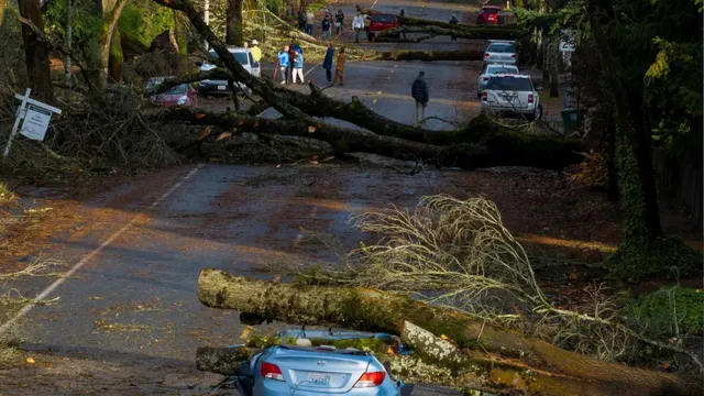
Bomb cyclone has caused widespread devastation across the US West Coast, resulting in at least two fatalities and knocking out power for hundreds of thousands. The storm, characterised by rapid intensification over a short period, brought heavy rainfall and winds reaching speeds of 80 km/h (50 mph) to Oregon, Washington, and California on Wednesday. With harsh weather conditions expected to persist through Friday, the impact of this storm continues to be felt across the region.
ALSO READ: Thai Woman Sentenced To Death For Poisoning 14 Friends With Cyanide
“Back-to-back powerful Pacific storm systems to impact the West Coast through the end of this week with heavy rain, life-threatening flooding, strong winds, and higher elevation mountain snow,” the National Weather Service (NWS) predicted in a social media post.
A 945 mb low pressure system continues to churn about 300 miles west of the Olympic Peninsula per the coordinated 00z (4 pm PST) surface analysis with @NWSOPC. Heavy rain, gusty winds, and mountain snow will continue across the Northwest through tomorrow as the system weakens. pic.twitter.com/lexILCNAk8
— NWS Weather Prediction Center (@NWSWPC) November 20, 2024
A bomb cyclone occurs when a storm system's atmospheric pressure suddenly drops by a significant amount, a process known as bombogenesis. This happens when pressure falls by at least 18 to 20 millibars within 24 hours, depending on the storm's latitude. The current storm is expected to drop pressure by 60 to 70 millibars over 24 to 36 hours, making it one of the fastest-deepening low-pressure systems on record, according to climate scientist Daniel Swain.
ALSO READ: World’s Best Cities For 2025 List Revealed: Check Where Mumbai And Delhi Rank
Power outages in Washington fluctuated throughout Tuesday evening, stabilising at around 460,000 by Wednesday afternoon. In Oregon, 2,800 customers were without power, while California had 38,000 outages and Nevada reported 10,000, including areas around Carson City and Reno. Several schools were closed in Seattle and Reno, and high winds led to the closure of the main highway between Reno and Carson City for semi-trucks. Additionally, all chairlifts at Mt. Rose Ski Resort near Lake Tahoe were shut down, as reported by AP.