
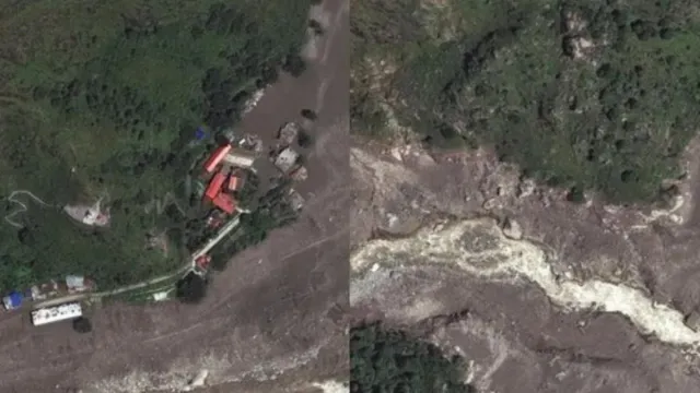
- Satellite images confirm Rasuwagadhi border crossing completely destroyed.
- Glacial collapse caused widespread devastation along Nepal-China border.
- Nepal-China trade route severely disrupted by flood damage.
Nepal Floods Latest News: Days after devastating floods struck Nepal, new satellite images have revealed the scale of destruction caused by a sudden flood in the Himalayas along the Nepal-China border.
The images show that the Rasuwagadhi border crossing was almost completely destroyed on August 26 after a powerful surge of rocks, ice, mud, and water swept through the area. More than 2,400 people remained missing, while nearly 2,500 people were evacuated as rescue teams raced against time amid intermittent rainfall in the flood-affected regions.
The disaster was triggered by an ice-rock avalanche following a glacial collapse near the Nepal-Tibet border that sent a torrent of water, mud and debris downstream through central Nepal on Wednesday, devastating several towns and villages, washing away homes, vehicles, roads and bridges, and damaging hydropower projects.
What do satellite images show?
According to a commercial satellite company, Vantor has released high-resolution before-and-after images of the disaster site. The images compare conditions on April 19, 2024, with those on August 27, 2026 and one day after the disaster.
Recommended For You
The pre-flood image shows a large, multi-storey border facility along the river, surrounded by roads, paved areas, and other infrastructure. In the post-flood image, most of the structures are buried beneath rocks, mud, and debris.
Our thoughts are with the communities affected by this week’s devastating flash floods in Nepal.
— Vantor (@vantortech) August 27, 2026
To support ongoing response and recovery efforts, Vantor has activated its Open Data Program, providing free access to high-resolution satellite imagery for frontline organizations… pic.twitter.com/RqQJdqAghr
Other satellite images from the affected area show widespread destruction, with homes, bridges, roads, and other infrastructure either washed away or buried. According to ABC News, the main multi-storey building and surrounding facilities at Rasuwagadhi were no longer visible in the post-flood imagery.
So far, the disaster has killed 626 people, while more than 2,000 remain missing.
Vantor's images show how dramatically the landscape has changed. A relatively narrow river corridor once surrounded by buildings and roads has been replaced by a much wider channel covered with sediment and debris. Vegetation has disappeared from parts of the valley, while large sections of the riverbed and surrounding areas have either been eroded away or buried under debris.
The destruction extends well beyond Rasuwagadhi. Satellite images of areas farther downstream show extensive damage around Syabrubesi, a tourism hub in the Langtang region, as well as major changes along the Trishuli River.
The loss of roads and bridges has further complicated rescue and relief operations. According to officials, more than 35 bridges and approximately 40 kilometres of roads have been damaged or destroyed, cutting off or restricting access to several affected areas.
ALSO READ: Nepal Floods: Miscreants Loot Rs 92 Lakh From Safe Washed Away In Trishuli River; 29 Arrested
Major China-Nepal trade route devastated
The destruction at Rasuwagadhi has also disrupted a strategically important trade and travel corridor connecting Nepal with China.
The crossing links Nepal with Gyirong in Tibet and serves as a major commercial and passenger gateway between the two countries. The damage has therefore affected not only local communities and rescue operations but also an important route for cross-border movement and trade.
According to the South China Morning Post, around 30 per cent of bilateral trade between Nepal and China in 2024 passed through the Gyirong-Rasuwagadhi route.
The destruction of the border crossing, combined with extensive damage to roads and bridges, has severely disrupted a critical link between Nepal and China at a time when authorities are still struggling to reach communities affected by the disaster.