
- Powerful "super" El Nino intensifying, pushing global temperatures to records.
- Viral maps show Earth red from heating, record temperatures.
- El Nino to persist until Feb 2027, causing global weather disruptions.
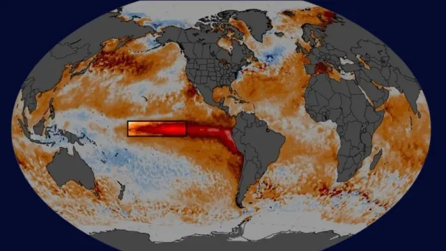
A strong El Nino event is currently intensifying over the Pacific Ocean. Weather experts and the United Nations have already warned that an unusually powerful "super" El Nino is currently unfolding and pushing into record-breaking territory, with several images on social media showing the Earth completely in "red."
The United Nations has stated that this year's weather phenomenon could be among the strongest witnessed since at least 1950.
According to the UN's weather and climate agency, the World Meteorological Organization (WMO), El Nino is combining with human-caused climate change, releasing trapped heat from the Pacific Ocean and causing unusually warm temperatures across almost the entire planet (except the United States).
As forecasted 5 months ago, we're going to need a bigger y-axis... Super-duper El Niño it is... https://t.co/8X6FK2JTIK
— Leon Simons 🌍 (@LeonSimons8) September 30, 2026
In a post on X, meteorologist Ryan Maue shared a climate map of the entire planet, noting that the Earth is almost entirely in red.
"El Nino continues at "maximum power" into the winter with planetary heating dialed up everywhere EXCEPT the United States."
Hopefully no one let their guard down after the quiet September because even during a Super El Niño especially with the climate fueled 88°F ocean surface in the Gulf in October, a major hurricane can go "beast mode" rapidly. We just saw a sequence of super-powerful Eastern Pacific hurricanes like Polo. Indeed, this spin-up w/potential sprint mode rapid intensification is a major fear of forecasters close land.
— Ryan Maue (@RyanWeather) October 6, 2026
He firmly agreed with the WMO assessment for this year and stated that El Nino will persist through February 2027.
Another climate scientist, Zeke Hausfather, also noted that this year's El Nino continues its climb into uncharted waters.
"Nino3.4 region anomalies are now at 3.4 degrees Celsius above normal (how fitting!), higher than any prior El Nino event on record."
ALSO READ: El Nino Risk: Maharashtra Imposes 10% Water Cut From October 16; Drinking Water Prioritised
Adding to this, weather expert Leon Simons called the weather phenomenon a "super-duper El Nino".
What Has WMO Said for 2026?
For 2026, the WMO stated that there is an overwhelming likelihood of above-average sea surface temperatures across large parts of the globe during the final months of the year.
It also noted that sea surface temperatures in the central and eastern tropical Pacific were expected to reach a record 3.7 degrees Celsius (6.7 degrees Fahrenheit) above normal from October to December.
For those who do not know, El Nino is a natural climate pattern that heats up the Pacific Ocean and disrupts weather around the world. It directly causes higher global temperatures and disrupts rainfall patterns across large regions, bringing drought to some areas and heavy rains to others. It typically occurs every two to seven years.
ALSO READ: Strong El Nino Builds Over Pacific, Raises Weather Risks For India Beyond Monsoon; What To Expect
Experts predict this weather phenomenon will stay strong and persist through February 2027. It is set to disrupt global weather patterns, leading to severe droughts in some regions and heavy rainfall in others, while raising overall global temperatures.
Experts have also warn of potential health risks and excess deaths globally during this period.